 |
| Yukon River |
Our entire trip through Alaska was amazing but to truly experience Alaska, or as the slogan goes “The way America was” you either have to fly on a bush plane into the middle of nowhere or you need to survive the Dalton Highway. This is real Alaska; its surreal. There is no population out here unless you count the tractor trailers as they barrel past. Its just mosquito’s, caribou, pipeline and the Brooks Range a mirage through the smokey evening stretching into the distance.
At the Yukon River we stopped at the “town” of Livingood. Livingood was a town of maybe ten people and I think we met them all between the gas pump and the cafe.
Livingood is one of the the last “big” towns. Its located at the Yukon River Crossing, the fifth largest river in North America. Even though it is one of the largest rivers in our country the entire bridge is wood, pretty amazing to think how fast tractor trailers fly across this bridge, plus it supports the pipeline. Livengood is 56 miles north of Fairbanks. They have a gas station, truck stop and cafe .  That is the whole town.
Livingood is about 76 miles to the Arctic Circle which is where we turned around. The next gas station after Livingood is in Coldfoot 120 miles up the long gravel road and the next gas stop after that is 240 miles up the Haul Road. This is the longest stretch of highway without any services in Northern America. From the Yukon River crossing we would drive north to the Arctic Circle, We left Fairbanks at 5 p.m. got to the Arctic Circle by 11:30 and planned to make it back to Fairbanks before morning. I wish we could have gone farther to Coldfoot and through all of the Brooks Range.
We filled up on gas (Which cost twice as much as it did in Cali, kind of ironic since your filling up literally next to the pipeline) and talked to the friendly locals in the cafe. You would expect for literally the middle of nowhere for the locals to be weird and inbred looking but the two young adults we talked to looked like they belonged in sunny Southern California. They gave us some helpful hints on driving and how not to total your rental car (Like the tourists they had talked to the week before) After taking a bunch of pictures on the wooden bridge we were back in the car and driving carefully up the gravel road, pumping the Gorillaz and singing along at the top of our lungs. Was it really 11p.m. we wondered as we drove into the endless smokey sunset.
The Dalton Highway or the Haul Road as locals call it follows the Trans-Alaska Pipeline System up to Prudhoe Bay. It was built in a hurry in 1974 to haul supplies up to the Pipeline. It parallels the pipeline 415 miles from Livengood all the way up to the Arctic Ocean and Prudhoe Bay. This stretch of highway is almost empty as you drive across the Brooks Range of mountains; there are only three towns along the Haul road, Coldfoot (Population 13), Wiseman (Population 22), and Dead Horse (Permanent population 25). When we drove through a huge wildfire was in progress that ended up burning over 350 acres. In the bush they mainly just let the big fires burn, knowing how often they get rain.
The smoke we could see in the distance and the ever approaching twilight made the whole drive kind of spooky. So did the black spruce that hugged the road through the far north of Alaska.
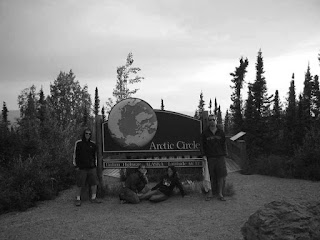
 There was almost no traffic expect for a few tractor trailers, it felt like we were the last car full of people on earth. It really did feel like the end of the world as we drove through the burnt forest, the smoke half obscuring the sun on the horizon. After more then a hour of driving down this dangerous gravel road we finally reached the turn off for the Arctic Circle. When we opened the doors of the car we were swarmed with black flies and mosquito’s. We wrapped tshirts around our faces, swatting at the bugs as we ran to the Arctic Circle keyosk, yanked cameras out of our pocket’s and snapped pictures as fast as we could, trying to smile and not swallow bugs.
 The whole ordeal was absolutely hilarious.
Our Alaska vacation was almost over. The next day we made the long drive back to Anchorage.
The next morning we were back on a flight to California, waving goodbye to Alaska and the vacation of a lifetime.


Comments
Wow, that sounds like a fabulous (and beautiful) adventure. Alaska is definitely on my bucket list.
Happy trails!
Karen
Love the name of those towns: “Livingood, Coldfoot, Deadhorse, Wiseman”. Thanks for the trip. I felt I was invited along, swatting at the mosquitoes and viewing the really weird light through all that smoke. Kind of like being on another planet, huh?