Montano De Oro is one of the most beautiful places in all of Southern California.
The camp ground is a little out of the way for a stay in the central coast area but it is just so pretty and so not crowded at all! During the week you never need reservations in the off season. It is one of my favorite local camp grounds and a real hidden gem located on the California coast line.
If you have time to do one hike at Montano de Oro the Hazard’s Peak is the hike to do.
The Hazard’s Peak hike takes you South over the Irish Hills. Most years they are super green and lush, unfortunately California is seeing a severe drought right now and nothing was as green as it normally is. This is still a awesome hike though as you gain over a thousand feet gradually in altitude before reaching the summit and the epic views of Morro Rock to the north.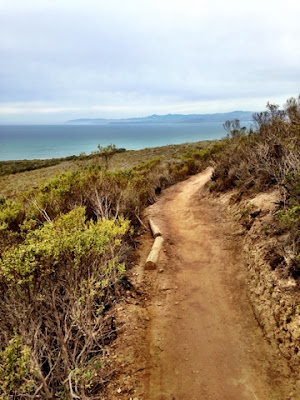

Since this route is so gradual you will see a ton of mountain bikers here but they are encouraged to strap bells to their bikes so you can hear them coming around the tight turns and chaparral.
I was told that rattle snakes are often seen here in the summer months. On this cool February morning I just saw a little green and yellow striped garden snack and was very pleased he was not a rattler.
Details for the Hazard Peak Hike
What you will need for this hike:
Sunscreen, snacks, 1-3 liters of water depending on how many miles you want to do.
First aid kit, wide brimmed hat
Sunscreen, snacks, 1-3 liters of water depending on how many miles you want to do.
First aid kit, wide brimmed hat
How much altitude you will encounter: 1,000 feet
How long is this hike: Six miles round trip
How do I get there? From San Luis Obispo, exit the 101 Freeway at Los Osos Valley Road and drive northwest toward Los Osos. After 11.2 miles, Los Osos Valley Road becomes Pecho Valley Road and turns sharply to the south. Continue the final 3.2 miles, entering Montaño De Oro State Park and passing through a eucalyptus grove before reaching the trailhead for Hazard Peak on the left, just before Spooner’s Cove. There is parking on both sides of the road.
